This briefing covers how the 2026 Anak Krakatau eruption affected air travel, schooling, and maritime activity in Indonesia, and what safety steps officials advised for residents and travelers. It also explains the eruption timeline, monitoring, and ongoing risks.
Aviation disruption and airport closures
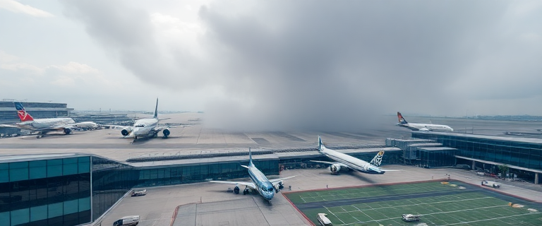
Air travel across western Indonesia faced sustained disruption as volcanic ash from Anak Krakatau spread over multiple airspaces. Eight airports were closed through Monday evening, including the four commercial airports managed by the state operator InJourney Airports in Jakarta, West Java, and Lampung, with airspace restrictions extending to Soekarno-Hatta and Halim Perdanakusuma in Jakarta and several surrounding facilities. The disruption led to a substantial operation-wide impact: 1,558 flights were delayed across the eight affected airports, and about 170,000 passengers were stranded. Within Jakarta, Soekarno-Hatta accounted for a large portion of flight disruptions, with hundreds of flights affected there alone.
The transport ministry described the situation as highly dynamic, noting that weather conditions hampered the ability to predict when activity would subside. In practical terms, airports and airlines worked to manage cascading disruptions that could affect fleet rotations, aircraft availability, and terminal capacity as travel plans shifted in real time.
Officials stressed that safety remained the top priority in every operational decision, even as travelers faced delays and cancellations. The disruption underscored how a major ash event can quickly reconfigure flight schedules and affect regional connectivity.
Timeline and current status of activity
The eruption at Anak Krakatau produced a continuous phase that lasted roughly 25 hours, ending on Sunday. After this peak, activity continued in a more moderate, intermittent pattern into Monday, with ongoing ash emissions and small, localised earthquakes observed by monitoring authorities. Satellite observations identified two distinct ash clouds: one plume rose to about 20,000 feet (6,100 meters) on the Java side and drifted northeast toward Jakarta and nearby regions, while a second cloud reached up to 50,000 feet (15,200 meters) and extended across parts of Banten, Lampung, and Bengkulu provinces as well as adjacent waters. The Darwin Volcanic Ash Advisory Centre and Indonesia’s volcanology agency monitored these clouds, providing guidance on airspace safety. In practical terms, air travel remained sensitive to weather and ash distribution, with authorities warning that the probability of further eruptions in the coming days remained high.
Authorities also noted that the eruption did not trigger a tsunami in this phase, a point repeatedly emphasized by the geology agency as monitoring continued.
Education disruptions and online learning
Beyond aviation, the eruption affected schooling in affected areas. The government authorized schools in regions impacted by volcanic ash to temporarily shift to online learning to reduce students’ exposure to ashfall and to allow local authorities to adapt classroom activities to conditions on the ground. In Jakarta and surrounding areas, classes moved online on Monday as part of this broader response. The measure covered areas including Jakarta, West Java, Banten, and Lampung, with authorities indicating it would continue as conditions warranted.
In addition to shifts in instruction, residents and students reported health and comfort impacts. Eye irritation from ash was noted among students and local residents, and fishing trips were canceled due to the eruption’s ash impact. These details illustrate the wider community disruption beyond the classroom.
Maritime safety and shipping impacts
Maritime operations in the Sunda Strait faced heightened risk due to ash and related hazards. Shipping authorities prohibited vessels from approaching an exclusion zone around the volcano—the radius of which is three kilometers—to protect ships from potential hazards such as volcanic bombs, hot rocks, and gas emissions. Mariners were advised to exercise heightened vigilance for navigation safety as conditions evolved.
The eruption’s ongoing activity and ash dispersion also meant broader risk management for shipping routes passing through the strait, prompting operators to reassess routes and schedules in light of ash advisories and visibility concerns. The situation highlighted how airborne ash can translate into maritime as well as air travel disruptions.
As part of a broader regional context, Anak Krakatau sits in a strait between Java and Sumatra and is known as the “child of Krakatau,” the historic Krakatau eruption site. Authorities emphasized that the main hazards include ash, gas, and other ejecta around the crater area, reinforcing the need for strict exclusion zones for safety.
Practical safety guidance for residents and travelers
Public health guidance advised residents and travelers to minimize outdoor activities when ashfall is present and to protect eyes and airways. Practical measures included wearing masks and eye protection, reducing outdoor exposure, and taking precautions while driving to maintain visibility. For people in affected areas, health authorities commonly recommended the use of respirators such as N95 or equivalent masks for ash protection, in line with general public health guidance for volcanic ash events. People were also advised to cover water sources and stay informed through official channels as conditions changed.
Travelers and residents were urged to monitor official airport and government social media for updates, especially given the potential for cascading disruptions to flight schedules and fleet rotations as the situation evolved. In addition to protecting health, the guidance emphasized practical steps for those stranded or awaiting reassignment, such as coordinating with airlines for rebooking or refunds and seeking alternative travel arrangements when needed.
Monitoring, authorities, and international coordination
Monitoring involved multiple agencies coordinating to assess risk and respond in real time. The head of Indonesia’s Geological Agency, Lana Saria, noted that Anak Krakatau had intensified activity since July, and that the September eruption was the strongest in that period. She cautioned that while eruptions continued, authorities could not reliably predict the next major event, and emphasized that the main hazards included ash, gas, and ejected hot material around the crater.
The eruption was tracked among both national and international monitoring networks, including satellite imagery that identified two distinct ash clouds at different altitudes. In addition to Indonesia’s volcanology agency, the Darwin Volcanic Ash Advisory Centre contributed to ash-cloud tracking, illustrating how international coordination supports aviation safety amid volcanic activity.
Public messaging consistently reiterated that while the eruption had not triggered a tsunami in this phase, ongoing monitoring remained essential as activity could resume or intensify. Local authorities and government ministries continued to publish updates to guide travelers, students, and mariners through the evolving situation.
Context and historical note
Indonesia sits on the Pacific Ring of Fire, a region of high volcanic and seismic activity where plate interactions frequently generate eruptions. The Anak Krakatau eruption is also connected, in historical memory, to the 2018 tsunami triggered by collapses on the Anak Krakatau island, which caused substantial loss of life and highlighted the ongoing hazards associated with volcanic islands in the Sunda Strait. The 2018 event demonstrated how eruptions can have far-reaching consequences—from air travel disruption to coastal hazards—and informs current risk awareness during the 2026 activity.
Meanwhile, authorities maintained that the nearest settlement to Anak Krakatau is more than 16 kilometers away, which is a factor in the decision not to issue an evacuation order during this phase. Official statements and monitoring data repeatedly emphasized staying clear of the crater and following guidance from the disaster-mitigation agency as the situation evolved.
What travelers and residents can do next
If you were affected by the disruption, take practical steps to minimize further inconvenience. Contact your airline promptly to explore rebooking or refunds, and monitor official airport channels for the latest updates on schedules and ground operations. Be prepared for cascading disruptions that can affect fleet rotations and airport capacity as airlines work to restore operations. For those still traveling, consider alternative routes or transportation options and stay informed through official sources.
For residents in ash-affected areas, continue following guidance from public health and disaster agencies. Use protective equipment when outdoors, manage exposure to ash by limiting outdoor activities, and take care with water sources and driving visibility. Remember that, even with a temporary end to the most intense phase, the situation can change, and further eruptions remain a possibility in the near term.